
Skeda:Fukushima I NPP 1975 medium crop rotated labeled.jpg

Madhësia e këtij shikimi: 300 × 600 pixel. Rezolucione të tjera: 120 × 240 pixel | 240 × 480 pixel.
Dokument origjinal (800 × 1.600 pixela, madhësia e skedës: 248 KB, tipi MIME: image/jpeg)
Përmbledhje
| Përshkrimi |
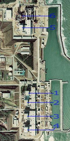
English: Fukushima I Nuclear Power Plant. Medium crop showing reactors labeled 1 to 5 and site for reactor 6. North is up.
日本語: 福島第一原子力発電所。 |
| Data | |
| Burimi | http://w3land.mlit.go.jp/cgi-bin/WebGIS2/WC_AirPhoto.cgi?IT=p&DT=n&PFN=CTO-75-30&PCN=C29B&IDX=21 |
| Autori | Ministry of Land, Infrastructure, Transport and Tourism |
| Versione tjera |
|
| Camera location | | View this and other nearby images on: OpenStreetMap |
|---|
Licencim

|
Krijuesi i kësaj skede, the Ministry of Land, Infrastructure, Transport and Tourism of Japan, lejon këdo ta përdorë për çdo qëllim, me kusht që krijuesi është i atribuar si duhet. Rishpërndarja, puna derivative, përdorimi komercial, dhe të gjitha përdorimet janë të lejuara. |
Atribuim:
Copyright © National Land Image Information (Color Aerial Photographs), Ministry of Land, Infrastructure, Transport and Tourism
|
 |
This image is copyrighted by the Ministry of Land, Infrastructure, Transport and Tourism of Japan. For terms of use, see the stipulation to use of National Land Information (in Japanese) and message from MLIT (in Japanese and English). When you display this image on an article, include the following phrase in the description: "Made based on National Land Image Information (Color Aerial Photographs), Ministry of Land, Infrastructure, Transport and Tourism".
|
Historiku i dosjes
Shtypni një datë/kohë për ta parë skedën ashtu si dukej në atë kohë.
| Data/Ora | Miniaturë | Përmasa | Përdoruesi | Koment | |
|---|---|---|---|---|---|
| e tanishme | 16 mars 2011 01:54 | | 800 × 1.600 (248 KB) | 84user | =={{int:filedesc}}== {{Information |Description={{en|1=Fukushima I Nuclear Power Plant. Medium crop showing reactors labeled 1 to 5 and site for reactor 6. North is up.}} {{ja|1=[[:ja:福島第一原子力発電所| |
Përdorimi i skedës
faqe lidhet tek kjo skedë:
Përdorimi global i skedës
Kjo skedë përdoret nga Wiki të tjera në vijim:
- Përdorimi në ar.wikipedia.org
- Përdorimi në ast.wikipedia.org
- Përdorimi në be-tarask.wikipedia.org
- Përdorimi në ca.wikipedia.org
- Përdorimi në cs.wikipedia.org
- Përdorimi në cv.wikipedia.org
- Përdorimi në de.wikipedia.org
- Përdorimi në de.wikinews.org
- Përdorimi në en.wikipedia.org
- Përdorimi në en.wikibooks.org
- Përdorimi në es.wikipedia.org
- Përdorimi në fi.wikipedia.org
- Përdorimi në fr.wikipedia.org
- Përdorimi në gl.wikipedia.org
- Përdorimi në he.wikipedia.org
- Përdorimi në hi.wikipedia.org
- Përdorimi në ja.wikipedia.org
- Përdorimi në ko.wikipedia.org
- Përdorimi në ko.wikinews.org
- Përdorimi në ms.wikipedia.org
- Përdorimi në nl.wikipedia.org
- Përdorimi në pl.wikipedia.org
- Përdorimi në pt.wikipedia.org
- Përdorimi në rm.wikipedia.org
- Përdorimi në ru.wikipedia.org
- Përdorimi në ta.wikipedia.org
- Përdorimi në th.wikipedia.org
- Përdorimi në zh.wikipedia.org